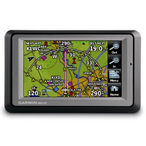
Deskripsi
The icons on the aera 660 are instantly familiar to anyone who’s used a Garmin GTN™ touchscreen GPS/NAV/COMM, G5000® integrated flight deck or even the Garmin Pilot™ app, and the intuitive interface allows you to quickly pan across the map screen, pinch to zoom and more. Meanwhile, the power button on the top accesses quick settings, including portrait or landscape orientation, volume and brightness.
Complete Flight Mapping
Physical dimensions: 5.5”W x 3.4”H x .8”D (14.1 x 8.7x 2.1 cm)
Display size, WxH: 4.35″W x 2.61″H (11.1 x 6.6 cm); 5.08″ diag (12.9cm)
Display resolution, WxH: 480 x 800; portrait and landscape orientation
Display type: touchscreen WVGA color TFT with white backlight
Weight: 8.64 ounces (245 g) with battery; 7.23 ounces (205 g) without battery
Battery: removable, rechargeable lithium-ion
Battery life: Up to 4 hours during most daytime conditions, (80% backlight) and wireless connectivity in the cockpit, e.g. GTX 345; up to 6 hours during typical nighttime conditions, (5% backlight) and without wireless connectivity.
SBAS/WAAS/GLONASS receiver: high-sensitivity with WAAS position accuracy
Voltage range: 10-35
IFR or VFR: VFR
Traffic Information Services (TIS) alerts compatible: yes
Accepts data cards: yes (microSD™ cards)
aera 660
Yoke mount with power cable
Battery
AC adapter
USB cable
Quick start manual and related documentation
Kantor Kami
Alamat : Komplek Karang Tengah Permai, Jl. Garuda Raya, T-A1 No.14C Ciledug Tangerang
Mobile : 082119696710
Mobile : 08192120879
Email : transsurvey1@gmail.com
KEPERCAYAAN ANDA ADALAH MODAL UTAMA KAM


Ulasan
Belum ada ulasan.