Deskripsi
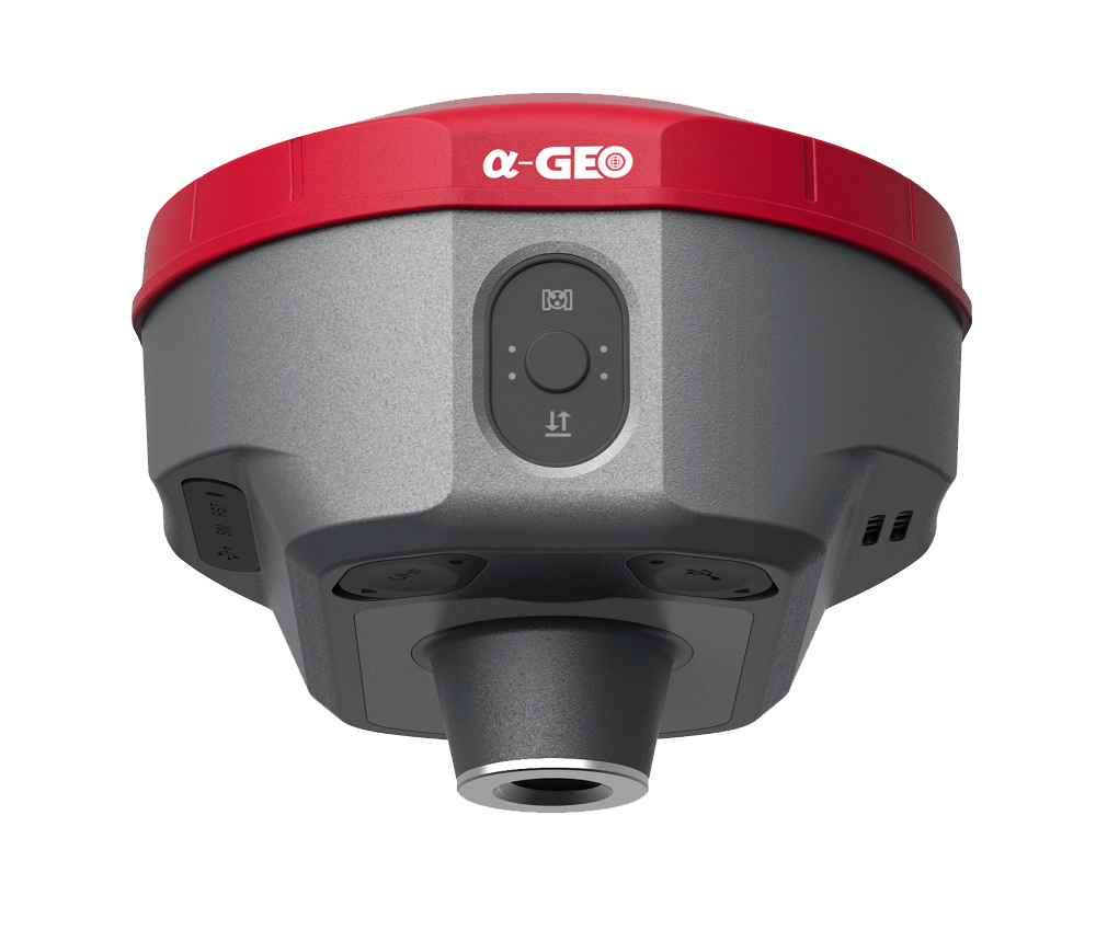
Alpha Geo MatrixII (a-GEO) dengan fitur terbaru AR CAMERA Ketika titik pengintaian ditandai langsung di tanah, surveyor dapat dengan mudah menemukan lokasi pasti dari titik pengintaian tersebut. Dengan mengikuti tanda panah pada peta kehidupan nyata, Anda dapat mengintai titik-titik sekaligus, tanpa harus menggerakkan tiang ke depan dan ke belakang, sehingga pekerjaan pengintaian menjadi lebih akurat dan efisien.
Jual GPS Geodetik Alpha Geo MatrixII
Jual GPS Geodetik Alpha Geo MatrixII Teknologi kalibrasi cepat pengukuran koordinat laser eksklusif yang dipatenkan di dunia dapat dengan mudah mencapai akurasi pengukuran tingkat sentimeter, menjadikan pengukuran lebih akurat dan mudah digunakan. Selain itu kamera yang digunakan pada peralatan mengatasi kesulitan membidik di bawah sinar matahari, membuat operasi pengukuran lapangan menjadi lebih cepat dan efisien.
FITUR a- GEO MATRIXII :
Multi constellation 1408 Satelit
AR Camera
Worry-free Storage 64GB
WiFi and WebUl
IMU Tilt Sensor 120 Derajat
GSM & UHF radio 410 MHz to 470 MHz
Battery & Power 7000mAh 12 jam
1P67
Working Mode Static, Network RTK, UHF RTK, PPK & etc.
SPESIFIKASI :
Performance specification
Satellite GPS: L1C/A, L1C, L2P(Y), L2C, L5
GLONASS: L1, L2, L3
BEIDOU: B1I, B2I, B3I, B1C, B2a, B2b
GALILEO: E1, E5a, E5b,E6
QZSS: L1, L2, L5, L6
SBAS: L1, L5
IRNSS: L5
Channels 1408 tracking Channels
Cold start <60 s
Hot start <15 s
Positioning output rate 1Hz – 20Hz
Signal Reacquisition <1s
RTK Initialization time <10s Initialization Reliability >99.99%
Time accuracy 20 ns
Positioning
Code differential GNSS positioning Horizontal: 0.25 m + 1 ppm RMS
Vertical: 0.50 m + 1 ppm RMS
SBAS differential positioning accuracy²: typically <5m 3DRMS
Static GNSS surveying Horizontal: 2.5 mm + 0.5 ppm RMS
Vertical: 5 mm + 0.5 ppm RMS
Real Time Kinematic Surveying
Single Baseline < 30 KM Horizontal: 8 mm + 1 ppm RMS
Vertical: 15 mm + 1ppm RMS
Network RTK Horizontal: 8 mm + 0.5 ppm RMS
Vertical: 15 mm + 0.5 ppm RMS
Physical
Material Magnesium alloy
Dimensions 120mm*72mm ( without bottom connector 20mm)
weight 0.76kg
Operating temperature -40°C to + 75°C
Storage temperature -55°C to + 85°C
Protection IP IP67 dust proof, protected from 30min immersion to depth of 1m
Shock Survive a 2m pole drop onto concrete
Vibration MIL-STD-810G
Humidity 100%, condensing
Power Supply
Battery Power: 9~24V DC external power input on 5 pin LEMO port
Support USB Type-C fast charging
Internal 7000mAh-7.4V lithium-ion battery
Battery Life
Rover Mode: 12 hours
Base Mode: 7 hours
Static Mode: 15 hours
Communication & Data Storage
I/O interface LEMO port (5pin)
Supports power input, serial port control,
and external radio communication
USB Type-C port Data download / Charging
Sim card slot Supports Nano-SIM
Antenna port UHF antenna interface
Radio modem Transmit power 1/1.5w switchable
Frequency band 410MHz-470MHz; supports to set the frequency
Protocols TrimTalk450s, SOUTH, Satel,PCC-EOT
Cellular Integrated full frequency multi band 4G modem,
supports WCDMA/CDMA2000/TDD-LTE/FDD-LTE
WIFI 802.11 b/g standard, access point & client mode,
supports access to hotspot for correction transmission
Bluetooth Bluetooth 5.2 Classical/BLE Proprietary double-mode
Data format RTCM2x, RTCM3x, CMR & CMR+, sCMRx
RINEX, NMEA outputs
Storage 64GB internal memory, supports cyclic storage; with ability
to collect over one year raw observation based on 5 seconds interval
Camera
AR 5M high-definition camera with large viewing angle and support
for live scene lofting
Laser assisted 5M high-definition camera, large viewing angle, auxiliary
laser measurement and aiming
System integration
OS system Intelligent LINUX operating system
Tilt Compensation IMU up to 120°(Calibration free)
Supported controllers All android devices with supported software
Design
Button Power key
Indicator Power indicator, data link indicator, satellite indicator, Bluetooth indicator
Voice Intelligent voice prompts
WEBUI Support WEBUI configuration


Ulasan
Belum ada ulasan.