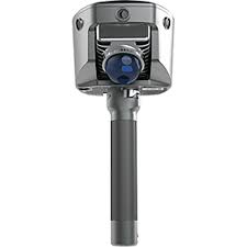
Deskripsi
Spesifikasi GPS Geodetic Hi-Target V700S SLAM RTK
-
GNSS Configuration
- Channel: 1408
- GNSS Signal:
- GPS: L1C/A, L1C, L2P(Y), L2C, L5
- BDS: B1I, B2I, B3I, B1C, B2a, B2b
- GLONASS: L1, L2, L3
- GALILEO: E1, E5a, E5b, E6
- QZSS: L1, L2, L5, L6
- NavIC: L5
- SBAS: L1, L2, L5
- PPP: B2b-PPP, E6-HAS
- Output format: ASCII: NMEA-0183, Binary
- Output rate: 1Hz~20Hz
- Static data format: GNS, Rinex
- Real Time Kinematic: RTCM2.X, RTCM3.X
- Network Mode: VRS, FKP, MAC, Support NTRIP protocol
-
System Configuration
- Operation system: Linux
- Storage: Circulating 512GB ROM
-
Accuracy and Reliability
- High-Precision Static: H: 2.5 mm + 0.1 ppm RMS, V: 3.5 mm + 0.4 ppm RMS
- Static and Fast Static: H: 2.5 mm + 0.5ppm RMS, V: 5 mm + 0.5ppm RMS
- PPK: H: 8mm + 1ppm RMS, V: 15mm + 1ppm RMS
- PPP: H: 10cm, V: 20cm
- Code Differential GNSS Positioning: H: ±0.25m+1ppm RMS SBAS: 0.5m (H), 0.85m (V), V: ±0.5m+1ppm RMS
- Real Time Kinematic (RTK): H: 8mm+1ppm RMS Initialization time: Typically <10s, V: 15mm+1ppm RMS Initialization reliability: Typically > 99.9%
- Tilt Survey Performance: 8mm+0.3mm/°tilt
- AR Stakeout: Support
- Image measurement: A single photo can acquire multiple point coordinates, with an accuracy of better than 5cm within 15 meters
- Real-time accuracy evaluation: Supports
-
Camera
- Pixel: 3 Professional HD Cameras
- Function: Support AR stakeout, image measurement, working distance 2~15m
-
Laser Scanner
- Range: 0.1~ 40m@10%, 0.1~ 70m@80%
- Point Measurement Rate: 200,000 pts/sec
- Laser product classification: Class 1 Eye Safe
- FOV: H: 160°, V: 59°
-
IMU
- Update rate: 200Hz
-
Communication
- I/O Interface: USB type C port; SMA antenna port; Nano SIM card slot
- Network: TDD-LTE,FDD-LTE,GSM
- WiFi: IEEE 802.11a/b/g/n/ac/ax,2.4GHz/5GHz,Wifi hotspot
- Bluetooth: Bluetooth 5.2
- Internal UHF Radio:
- Power:0.5W/1W Adjustable Frequence: 410MHz~470MHz
- Protocol: HI-TARGET, TRIMTALK450S, TRIMMARK III, SATEL-3AS, TRANSEOT, etc.
- Channel: 116(16 scalable)
-
Sensor
- Electronic bubble: Supports
- Tilt Survey: Built-in High-precision IMU Module
-
Control Panel
- Physical button: Single button
- Display: 2.8 inch, 480×640 pixel touchable screen
- LED lights: Mode, Accuracy, Network
-
Application
- Advanced function: NFC, WebUI, Firmware upgrade via U-disk
- Intelligence application: Intelligent Voice, Self-check
- Remote service: Message push, online upgrade, remote control
-
Physical
- Power:
- Lithium battery, portable charger
- RTK rover(UHF/Cellular): up to 10 hours, SLAM mode: up to 5 hours
- USB 45W fast charging, fully charged in 2 hours
- Size: fully charged in 2 hours
- Weight: 68kg
- Power:
-
Environments
- Water/dustproof: IP64
- Humidity: 100% non-condensing
- Operation temperature: -20°C~+55°C
- Storage temperature: -40°C~+70°C
Kelengkapan
- 1x V700S GNSS Receiver
- 1x Battery
- 1x Qpad X9 Tablet
- 1x Radio Receiving Antenna
- 1x Survey Pole Hi-Target (new logo) 2.2m
- 1x Power adapter
- 2x USB data cable
- 1x Double-socket tablet mount
- 1x Tablet bracket
- 1x Tablet mount
- 1x Fixing screw
- 1x Control Point Benchmark
- 1x Survey Benchmark
- 1x Rover plastic case
- 1x Certificate of quality
- 1x Warranty card
- 1x Plastic case PVC label (Hi-Target)
- 1x Envelope
- 1x Hi-Target software
- 1x Hi-LiDar (optional)


Ulasan
Belum ada ulasan.